


No Fly Zone
Descrizione di No Fly Zone
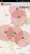
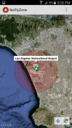
This app contains over 46,000 airports around the world which can be displayed quickly and easily when flying RC models. When flying RC/UAV's commercially, these areas are considered "No Fly Zones" based on your geographic location.
For example when flying UAV's in Canada, Transport Canada has set a 9km no fly zone around Airports without proper legal authorization.
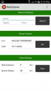
By default this app sets a 9km radius around Airports and will display all airports within 30km of your marker.
These settings can be adjusted depending on geographic location and rules in your area.</div> <div jsname="WJz9Hc" style="display:none">Questa applicazione contiene oltre 46.000 aeroporti in tutto il mondo, che possono essere visualizzati in modo rapido e facilmente quando volare modelli RC. Quando si vola RC / UAV in commercio, queste aree sono considerati "No Fly Zone" in base alla posizione geografica.
Per esempio durante il volo UAV di in Canada, Transport Canada ha stabilito un 9 km no fly zone intorno a Aeroporti senza adeguata autorizzazione legale.
Per impostazione predefinita, questa applicazione imposta un raggio di 9 chilometri intorno Aeroporti e mostrerà tutti gli aeroporti entro 30 km di vostro marcatore.
Queste impostazioni possono essere regolate a seconda della posizione geografica e le regole nella vostra zona.</div> <div class="show-more-end">
No Fly Zone - Versione 3.0
(22-04-2016)No Fly Zone - Informazioni APK
Versione APK: 3.0Pacchetto: com.reelmedia.NoFlyZoneUltima versione di No Fly Zone


 3.98
3.98App nella stessa categoria

Potrebbe piacerti anche...


